Mamudpur, Arambagh
Village in West Bengal, India
22°53′26″N 87°35′52″E / 22.890523°N 87.597872°E / 22.890523; 87.597872 India
India (2011)
712612
Mamudpur is a village in the Goghat II CD block in the Arambagh subdivision of Hooghly district in the Indian state of West Bengal.
Geography


8km
5miles
5miles

Damodar
River
River
Rupnarayan
River
River
Mundeswari
River
River
Dwarakeswar
River
River
Shyambazar
H

Satberia
H
Parul
H
Memanpur
H
Mamudpur
H
Madhabpur
H
Kanpur
HV
Kayapat
H
Hat Basantapur
H
Hamirbati
H
Gourhati
H
Fului
H
Dihi
Bayara
Bayara
H
Bhalia
H
Bali Dewanganj
H
Badanganj
H
Gar Mandaran
H
Arambag
M
Dakshin Narayanpur
R
Natibpur
R
Shrirampur
R
Radhanagore
R
Keshabpur
R
Bengai
R
Pursurah
R
Kamarpukur
R
Khanakul
R
Goghat
R
Cities and towns in Arambagh subdivision in Hooghly district
M: municipal city/ town, R: rural/ urban centre, H: historical/ religious centre
Owing to space constraints in the small map, the actual locations in a larger map may vary slightly
M: municipal city/ town, R: rural/ urban centre, H: historical/ religious centre
Owing to space constraints in the small map, the actual locations in a larger map may vary slightly
Area overview
The Arambagh subdivision, presented in the map alongside, is divided into two physiographic parts – the Dwarakeswar River being the dividing line. The western part is upland and rocky – it is the extension of the terrain of neighbouring Bankura district. The eastern part is flat alluvial plain area. The railways, the roads and flood-control measures have had an impact on the area.[1] The area is overwhelmingly rural with 94.77% of the population living in rural areas and only 5.23% residing in urban areas.[2]
Note: The map alongside presents some of the notable locations in the subdivision. All places marked in the map are linked in the larger full screen map.
Location
Mamudpur is located at 22°53′26″N 87°35′52″E / 22.890523°N 87.597672°E / 22.890523; 87.597672
Demographics
As per the 2011 Census of India, Mamudpur had a total population of 2,109 of which 1,074 (51%) were males and 1,035 (49%) were females. Population in the age range 0–6 years was 238. The total number of literate persons in Mamudpur was 1,280 (68.41% of the population over 6 years).[3]
Culture
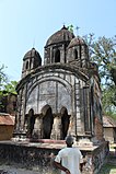
David J. McCutchion mentions a pancha ratna with rich terracotta façade in Mamudpur.[4]
Mamudpur picture gallery
-
 Vishnu temple of Rai family, a pancha ratna, built in 1806
 -
 Terracotta panel in Vishnu temple.
 -
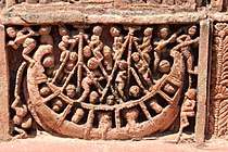 Terracotta panel in Vishnu temple.
 -
 A small temple.
 -
 Another pancha ratna temple.


References
- ^ "District Census Handbook: Hugli, Series-20, Part XIIA" (PDF). Physiography, Page 17-19. Directorate of Census Operations, West Bengal, 2011. Retrieved 25 September 2020.
- ^ "District Statistical Handbook 2014 Hooghly". Table 2.2, 2.4(a). Department of Planning and Statistics, Government of West Bengal. Retrieved 25 September 2020.
- ^ "2011 Census – Primary Census Abstract Data Tables". West Bengal – District-wise. Registrar General and Census Commissioner, India. Retrieved 22 September 2020.
- ^ McCutchion, David J., Late Mediaeval Temples of Bengal, first published 1972, reprinted 2017, pages 46. The Asiatic Society, Kolkata, ISBN 978-93-81574-65-2
External links
Wikimedia Commons has media related to Mamudpur, Goghat.
- v
- t
- e
Cities, towns and locations in Hooghly district
municipalities
and
census towns
other than
cities and towns
 Hooghly topics
- Template:Srirampore subdivision
 People from Hooghly district
- Villages in Hooghly district


 India portal
 | This article about a location in the Hooghly district of West Bengal is a stub. You can help Wikipedia by expanding it. |
- v
- t
- e


