Kanpur, Hooghly
Village in West Bengal, India
22°50′11″N 87°49′39″E / 22.8363°N 87.8276°E / 22.8363; 87.8276 India
India (2011)
712413
Kanpur is a village in the Arambagh CD block in the Arambagh subdivision of Hooghly district in the Indian state of West Bengal.
Geography


8km
5miles
5miles
Damodar
River
River
Rupnarayan
River
River
Mundeswari
River
River
Dwarakeswar
River
River
Shyambazar
H

Satberia
H
Parul
H
Memanpur
H
Mamudpur
H
Madhabpur
H
Kanpur
HV
Kayapat
H
Hat Basantapur
H
Hamirbati
H
Gourhati
H
Fului
H
Dihi
Bayara
Bayara
H
Bhalia
H
Bali Dewanganj
H
Badanganj
H
Gar Mandaran
H
Arambag
M
Dakshin Narayanpur
R
Natibpur
R
Shrirampur
R
Radhanagore
R
Keshabpur
R
Bengai
R
Pursurah
R
Kamarpukur
R
Khanakul
R
Goghat
R
Cities and towns in Arambagh subdivision in Hooghly district
M: municipal city/ town, R: rural/ urban centre, H: historical/ religious centre
Owing to space constraints in the small map, the actual locations in a larger map may vary slightly
M: municipal city/ town, R: rural/ urban centre, H: historical/ religious centre
Owing to space constraints in the small map, the actual locations in a larger map may vary slightly
Location
Kanpur is located at 22°50′11″N 87°49′39″E / 22.8363°N 87.8276°E / 22.8363; 87.8276
Area overview
The Arambagh subdivision, presented in the map alongside, is divided into two physiographic parts – the Dwarakeswar River being the dividing line. The western part is upland and rocky – it is extension of the terrain of neighbouring Bankura district. The eastern part is flat alluvial plain area. The railways, the roads and flood-control measures have had an impact on the area.[1] The area is overwhelmingly rural with 94.77% of the population living in rural areas and 5.23% of the population living in urban areas.[2]
Note: The map alongside presents some of the notable locations in the subdivision. All places marked in the map are linked in the larger full screen map.
Demographics
As per the 2011 Census of India, Kanpur had a total population of 2,657 of which 1,361 (51%) were males and 1,296 (49%) were females. Population in the age range 0–6 years was 260. The total number of literate persons in Kanpur was 1,967 (82.06% of the population over 6 years).[3]
Culture
David J. McCutchion mentions the Kanakesvara temple as an eka ratna with open verandah all round having arhes on wall sections He feels that such eka ratna design may have originated from the rekha deul. It is brick temple, possibly built in the 19th century, having slight plasterwork.[4]
The photographer has added a note: The Kanakeswar Shiva temple is a prominent Hindu religious centre in the area. The Gajan festival of Lord Shiva and the Kalu Rai fair are celebrated enthusiastically.
Kanpur picture gallery
-
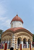 Kanakeswar Shiva temple, eka ratna, with verandah all round.
 -
 Plaster work
 -
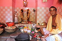 Inside the temple


References
- ^ "District Census Handbook: Hugli, Series-20, Part XIIA" (PDF). Physiography, Page 17-19. Directorate of Census Operations, West Bengal, 2011. Retrieved 25 September 2020.
- ^ "District Statistical Handbook 2014 Hooghly". Table 2.2, 2.4(a). Department of Planning and Statistics, Government of West Bengal. Retrieved 25 September 2020.
- ^ "2011 Census – Primary Census Abstract Data Tables". West Bengal – District-wise. Registrar General and Census Commissioner, India. Retrieved 22 September 2020.
- ^ McCutchion, David J., Late Mediaeval Temples of Bengal, first published 1972, reprinted 2017, pages 38, 75. The Asiatic Society, Kolkata, ISBN 978-93-81574-65-2
External links
Wikimedia Commons has media related to Kanpur, Hooghly.
- v
- t
- e
Cities, towns and locations in Hooghly district
municipalities
and
census towns
other than
cities and towns
 Hooghly topics
- Template:Srirampore subdivision
 People from Hooghly district
- Villages in Hooghly district


 India portal


