Victoria, Honduras
Municipality in Yoro, Honduras
14°56′18″N 087°23′33″W / 14.93833°N 87.39250°W / 14.93833; -87.39250 (2015)
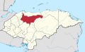
Victoria is a municipality in the Honduran department of Yoro.[1]
It is served by Victoria Airport, a 700 metres (2,300 ft) grass airstrip.
Demographics
At the time of the 2013 Honduras census, Victoria municipality had a population of 33,019. Of these, 88.60% were Mestizo, 7.14% Indigenous (6.69% Tolupan), 3.63% White, 0.61% Black or Afro-Honduran and 0.02% others.[2]
References
External links
- OpenStreetMap - Victoria
- v
- t
- e
Yoro Department
Capital: Yoro
 | This Honduras location article is a stub. You can help Wikipedia by expanding it. |
- v
- t
- e


