Thuận An
You can help expand this article with text translated from the corresponding article in Vietnamese. (October 2023) Click [show] for important translation instructions.
- View a machine-translated version of the Vietnamese article.
- Machine translation, like DeepL or Google Translate, is a useful starting point for translations, but translators must revise errors as necessary and confirm that the translation is accurate, rather than simply copy-pasting machine-translated text into the English Wikipedia.
- Do not translate text that appears unreliable or low-quality. If possible, verify the text with references provided in the foreign-language article.
- You must provide copyright attribution in the edit summary accompanying your translation by providing an interlanguage link to the source of your translation. A model attribution edit summary is
Content in this edit is translated from the existing Vietnamese Wikipedia article at [[:vi:Thuận An]]; see its history for attribution. - You may also add the template
{{Translated|vi|Thuận An}}to the talk page. - For more guidance, see Wikipedia:Translation.
Provincial city in Southeast, Vietnam
Thuận An Thành phố Thuận An | |
|---|---|
Provincial city (Class-3) | |
| Thuận An City | |
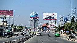 Street scene in Thuận An | |
 | |
| 10°54′18″N 106°41′58″E / 10.90500°N 106.69944°E / 10.90500; 106.69944 | |
| Country |  Vietnam Vietnam |
| Region | Southeast |
| Province | Bình Dương |
| Area | |
| • Total | 32.3 sq mi (83.69 km2) |
| Population (2021) | |
| • Total | 618,984 |
| • Density | 19,150/sq mi (7,394/km2) |
| Time zone | UTC+7 (Indochina Time) |
| Postcode | 725 |
| Website | http://thuanan.binhduong.gov.vn |
Thuận An is a city of Bình Dương Province in the Southeast region of Vietnam. It is situated about 18 kilometres (11 mi) northeast of the centre of Ho Chi Minh City.[1] As of November 3, 2021 the city had a population of 618,984.[2] The town covers an area of 83.7 km². The center of this town - Lái Thiêu - is famous for its ceramic and fruits.
Administrative divisions
Thuận An has nine wards (Lái Thiêu, An Thạnh, Vĩnh Phú, Bình Hòa, Bình Chuẩn, Thuận Giao, An Phú, Hưng Định and Bình Nhâm) and one rural commune (An Sơn).
Geography
Thuận An Dĩ An to the east, Thủ Dầu Một to the north. District 12, Ho Chi Minh City to the west and Thủ Đức to the south.
References
- ^ Google (12 October 2022). "Thuận An" (Map). Google Maps. Google. Retrieved 12 October 2022.
- ^ Công văn số 157/TB-SYT: Đánh giá cấp độ dịch Covid-19 trên địa bàn tỉnh Bình Dương (tính đến 18g00’ ngày 03 tháng 11 năm 2021). "Dân số đến 03 tháng 11 năm 2021 - tỉnh Bình Dương" (PDF).
{{cite web}}: CS1 maint: numeric names: authors list (link)
Wikimedia Commons has media related to Category:Thuan An.
- v
- t
- e
Cities in Vietnam
| Special |
|
|---|---|
| Class-1 |
| Class-1 |
|---|
| Class-1 | |
|---|---|
| Class-2 | |
| Class-3 |
|
Districts of Southeast Vietnam | ||
|---|---|---|
| Ho Chi Minh City |
|  |
| Bà Rịa–Vũng Tàu province | ||
| Bình Dương province |
| |
| Bình Phước province |
| |
| Đồng Nai province | ||
| Tây Ninh province |
| |
※ denotes provincial seat | ||
 | This article about a location in Bình Dương Province, Vietnam is a stub. You can help Wikipedia by expanding it. |
- v
- t
- e


