Sivalik Hills
Mountain range in India and Nepal

The Sivalik Hills, also known as the Shivalik Hills and Churia Hills, are a mountain range of the outer Himalayas. The literal translation of "Sivalik" is 'tresses of Shiva'.[1] The hills are known for their numerous fossils, and is also home to the Soanian Middle Paleolithic archaeological culture.[2]
Geography
The Sivalik Hills are a mountain range of the outer Himalayas that stretches over about 2,400 km (1,500 mi) from the Indus River eastwards close to the Brahmaputra River, spanning the northern parts of the Indian subcontinent. It is 10–50 km (6.2–31.1 mi) wide with an average elevation of 1,500–2,000 m (4,900–6,600 ft). Between the Teesta and Raidāk Rivers in Assam is a gap of about 90 km (56 mi).[3] They are well known for their Neogene and Pleistocene aged vertebrate fossils.[4]
Geology

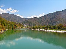
Ganga river cutting through the Sivalik hills

View of the Sivalik hills from Sukhna lake at dawn
Geologically, the Sivalik Hills belong to the Tertiary deposits of the outer Himalayas.[5] They are chiefly composed of sandstone and conglomerate rock formations, which are the solidified detritus of the Himalayas[5] to their north; they are poorly consolidated. The sedimentary rocks comprising the hills are believed to be 16–5.2 million years old.[6]
They are bounded on the south by a fault system called the Main Frontal Thrust, with steeper slopes on that side. Below this, the coarse alluvial Bhabar zone makes the transition to the nearly level plains. Rainfall, especially during the summer monsoon, percolates into the Bhabar, then is forced to the surface by finer alluvial layers below it in a zone of springs and marshes along the northern edge of the Terai or plains.[7]
Prehistory
The Sivalik Hills are well known for fossils of vertebrates, spanning from the Early Miocene, until the Middle Pleistocene, around 18 million to 600,000 years ago.[8][9]
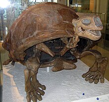
Some of the best known fossils from the hills include Megalochelys atlas, the largest known tortoise to have ever existed,[10] Sivatherium giganteum, the largest known giraffid, [11] and the ape Sivapithecus.[12]
Remains of the Lower-Middle Paleolithic Soanian culture dating to around 500,000 to 125,000 years Before Present were found in the Sivalik region.[13] Contemporary to the Acheulean, the Soanian culture is named after the Soan Valley in the Sivalik Hills of Pakistan. The Soanian archaeological culture is found across Sivalik region in present-day India, Nepal and Pakistan.[2]
See also
- Subranges of Sivalik (from north to south)
- Geological subdivisions of Himalayas (from north to south)
- Indus-Yarlung suture zone
- Karakoram fault system
- Nyenchen Tanglha Mountains
- Main Himalayan Thrust
- Lower/Lesser Himalaya
- Geographical subdivisions of Himalayas (from east to west)
- Eastern Himalaya
- Indian Himalayan Region, Geology of Bhutan and Geology of Nepal
- Jammu and Kashmir (union territory), Geography of Ladakh, Gilgit-Baltistan and Geology of Pakistan
References
- ^ Balokhra, J. M. (1999). The Wonderland of Himachal Pradesh (Revised and enlarged fourth ed.). New Delhi: H. G. Publications. ISBN 9788184659757.
- ^ a b Chauhan, P. (2016). "A decade of paleoanthropology in the Indian Subcontinent. The Soanian industry reassessed". In Schug, G. R.; Walimbe, S. R. (eds.). A Companion to South Asia in the Past. Oxford, Chichester: John Wiley & Sons. p. 39. ISBN 978-1-119-05547-1.
- ^ Kohli, M. S. (2002). "Shivalik Range". Mountains of India: Tourism, Adventure and Pilgrimage. Indus Publishing. pp. 24–25. ISBN 978-81-7387-135-1.
- ^ Kaur, A. P. (2022). "New fossil mammalian assemblages and first record of ostrich from the Pinjore (Pinjor) formation (2.58–0.63 Ma) of Siwalik Hills near Chandigarh, northern India". Quaternary Science Reviews. 293: 107694. doi:10.1016/j.quascirev.2022.107694.
- ^ a b Chisholm, Hugh, ed. (1911). "Siwalik Hills" . Encyclopædia Britannica. Vol. 25 (11th ed.). Cambridge University Press. pp. 163–164.
- ^ Gautam, P.; Fujiwara, Y. (2000). "Magnetic polarity stratigraphy of Siwalik Group sediments of Karnali River section in western Nepal". Geophysical Journal International. 142 (3): 812–824. Bibcode:2000GeoJI.142..812G. doi:10.1046/j.1365-246x.2000.00185.x. hdl:2115/38248.
- ^ Mani, M.S. (2012). Ecology and Biogeography in India. Springer Science & Business Media. p. 690.
- ^ Nanda, A.C. (2002). "Upper Siwalik mammalian faunas of India and associated events". Journal of Asian Earth Sciences. 21 (1): 47–58. doi:10.1016/S1367-9120(02)00013-5.
- ^ Patnaik, R. (2013). "Indian Neogene Siwalik Mammalian Biostratigraphy. An Overview". Fossil Mammals of Asia. New York Chichester, West Sussex: Columbia University Press. doi:10.7312/wang15012-017.
- ^ Rhodin, A.G.J.; Thomson, S.; Georgalis, G.; Karl, H.-V.; Danilov, I.G.; Takahashi, A.; de la Fuente, M.S.; Bourque, J.R.; Delfino M.; Bour, R.; Iverson, J.B.; Shaffer, H.B.; van Dijk, P.P.; et al. (Turtle Extinctions Working Group) (2015). "Turtles and tortoises of the world during the rise and global spread of humanity: first checklist and review of extinct Pleistocene and Holocene chelonians". Chelonian Research Monographs. 5 (8): 000e.1–66. doi:10.3854/crm.5.000e.fossil.checklist.v1.2015. hdl:11336/62240.
- ^ Basu, Christopher; Falkingham, Peter L.; Hutchinson, John R. (January 2016). "The extinct, giant giraffid Sivatherium giganteum: skeletal reconstruction and body mass estimation". Biology Letters. 12 (1): 20150940. doi:10.1098/rsbl.2015.0940. PMC 4785933. PMID 26763212.
- ^ Kelley, J. (1988). "A new large species of Sivapithecus from the Siwaliks of Pakistan". Journal of Human Evolution. 17 (3): 305–324. doi:10.1016/0047-2484(88)90073-5.
- ^ Lycett, S. J. (2007). "Is the Soanian techno-complex a Mode 1 or Mode 3 phenomenon? A morphometric assessment". Journal of Archaeological Science. 34 (9): 1434–1440. doi:10.1016/j.jas.2006.11.001.
External links
Wikimedia Commons has media related to Shivalik Hills.
Wikisource has the text of the 1911 Encyclopædia Britannica article "Siwalik Hills".
27°46′N 82°24′E / 27.767°N 82.400°E / 27.767; 82.400
- v
- t
- e
Punjab geography
- Bagar
- Bars (Sandal • Kirana • Neeli • Ganji • Gondal • Jungle)
- Beas River
- Bhatiore
- Bhattiana
- Chenab River
- Chhachh
- Cholistan Desert
- Derajat
- Doaba
- Doabs (Indus Sagar • Chaj • Rachna • Bari • Bist)
- Duggar
- Ghaggar river
- Indus River
- Jhelum River
- Kachhi
- Kala Chitta Range
- Kirana Hills
- Majha
- Malwa
- Margalla Hills
- Puadh
- Pothwar
- Ravi River
- Sakesar
- Salt Range
- Sivalik Hills
- Soan River
- Soon Valley
- Sulaiman Mountains
- Sutlej River
- Thal Desert

Authority control databases | |
|---|---|
| International |
|
| National |
|


