Saint Bernard, Louisiana
Unincorporated community in Louisiana, United States
Saint Bernard San Bernardo (Spanish) | |
|---|---|
Unincorporated community | |
29°52′02″N 89°51′31″W / 29.86722°N 89.85861°W / 29.86722; -89.85861 | |
| Country |  United States United States |
| State |  Louisiana Louisiana |
| Parish |  St. Bernard Parish St. Bernard Parish |
| MCD | District E |
| Historic colonies | Louisiana (New Spain) Louisiana (New France) |
| Established | 1783 |
| Named for | patron saint of Bernardo de Gálvez |
| Elevation | 0.9 m (3 ft) |
| Demonym(s) | tornero, -ra |
| Time zone | UTC−6 (Central) |
| • Summer (DST) | UTC−5 (Central) |
| ZIP code | 70085 |
| Area code | 504 |
| GNIS feature ID | 1628099 |
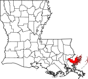
Saint Bernard (Spanish: San Bernardo [sam beɾˈnaɾðo]) is an unincorporated community in St. Bernard Parish, Louisiana, United States. The community is located on Louisiana State Highway 300, east of the Mississippi River and 8 miles (13 km) southeast of Chalmette.
Saint Bernard is home to four sites on the National Register of Historic Places: the Dr. Louis A. Ducros House, the Kenilworth Plantation House, Magnolia Mound, and the Sebastopol Plantation House.[1]
References
- ^ "National Register Information System". National Register of Historic Places. National Park Service. July 9, 2010.
- v
- t
- e
Municipalities and communities of St. Bernard Parish, Louisiana, United States
Parish seat: Chalmette

communities
- Louisiana portal
- United States portal
 | This Louisiana state location article is a stub. You can help Wikipedia by expanding it. |
- v
- t
- e


