Myall Lakes National Park
Protected area in New South Wales, Australia
32°29′41″S 152°20′11″E / 32.49472°S 152.33639°E / -32.49472; 152.33639New South Wales
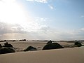
Myall Lakes National Park is a national park located in New South Wales, Australia, 236 kilometres (147 mi) north of Sydney. It encompasses one of the state's largest coastal lake systems Myall Lakes, and includes Broughton Island. The park includes 40 kilometres of beaches and rolling sand dunes. Myall Lakes is also one of the most visited parks in New South Wales.[1]
History
The Worimi Aboriginal people had inhabited the Myall Lakes National Park land area for its abundance of natural resources. These natural resources had offered a traditional hunter-gatherer lifestyle for the Worimi people. The park includes important spiritual sites that are an important part of the identity of local Aboriginal people. Dark Point Aboriginal Place served as a location for the Worimi people to gather together for ceremonies and feasts and has been of significance to Worimi people for at least 4000 years.[2]
Environment
Myall Lakes National Park incorporates a patchwork of freshwater lakes, the ocean, islands, native flora, dense littoral rainforest and beaches.
Since 1999, Myall Lakes has been listed under the Ramsar Convention.[3]
Fauna
The lakes support a large variety of birds including bowerbirds, white-bellied sea eagle and tawny frogmouths.[4]
Other native Fauna which can be seen in the park includes the nocturnal long-nosed bandicoot which has grey-brown fur and a pointed snout for which it uses to forage for worms and insects. The Striped marsh frog can be found near ponds and swamps and has a distinct sound which can be heard all year round.[5] The Eastern swamp crayfish was first discovered here.[6]
Climate
The average high temperature during the summer season averages between 19 °C and 27 °C. The highest temperature recorded at the park is 41.5 °C.[7] The average temperature during the winter season averages between 10 °C and 19 °C with the lowest temperature on record being 1.1 °C.[7] The wettest month typically occurs in May while the driest month occurs in November. The area's highest recorded rainfall in one day is 257.8mm.[7]
Gallery
-
 Dingo at Myall Lakes National Park
 -
 Dee's Corner
 -
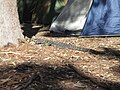 Goanna at one of the campsites
 -
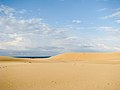 Sand dunes at Myall Lakes National Park
 -
 Local fauna at Myall Lakes National Park
 -
 Sand dunes at Myall Lakes National Park
 -
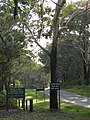 Park entrance at Myall Lakes National Park


Notes and references
- ^ "MYALL LAKES NATIONAL PARK - FORSTER AND TAREE AREA". Visit NSW - Destination NSW. Retrieved 20 May 2017.
- ^ "Myall Lakes National Park". NSW National Parks and Wildlife Service. Retrieved 20 May 2017.
- ^ "Myall Lakes: Internationally recognised wetlands". NSW National Parks and Wildlife Service. Retrieved 4 September 2018.
- ^ Dragicevich, Peter (August 2014). East Coast Australia (5th ed.). Printed in China: Lonely Planet Publications Pty Ltd. pp. 126–127. ISBN 9781-74220-425-3.
- ^ "Myall Lakes National Park". Skip to contentNSW National Parks and Wildlife Service. Retrieved 20 May 2017.
- ^ McCormack, Robert B. (4 April 2014). "The eastern swamp crayfish Gramastacus lacus sp. n. (Decapoda, Parastacidae) a new species of freshwater crayfish from coastal New South Wales, Australia". ZooKeys (398). Pensoft Publishers: 53–67. doi:10.3897/zookeys.398.7544. PMC 3978226. PMID 24715801.
- ^ a b c "Myall Lakes National Park Visitor Info". Skip to contentNSW National Parks and Wildlife Service. Retrieved 20 May 2017.
See also
- Protected areas of New South Wales
 Myall Lakes National Park travel guide from Wikivoyage
- v
- t
- e
- Abercrombie
- Breelong
- Capertee
- Conimbla
- Coolah Tops
- Drillwarrina
- Gardens of Stone
- Garrawilla
- Goobang
- Goulburn
- Kanangra-Boyd
- Lachlan Valley
- Marrangaroo
- Nangar
- Popran
- Turon
- Warrumbungle
- Weddin Mountains
- Wollemi
- Brindingabba
- Culgoa
- Gundabooka
- Kalyarr
- Kemendok
- Kinchega
- Koonaburra
- Mallee Cliffs
- Mungo
- Mutawintji
- Narriearra Caryapundy Swamp
- Paroo-Darling
- Sturt
- Toorale
- Yanga
- Barakee
- Barrington Tops
- Belford
- Ben Halls Gap
- Biriwal Bulga
- Booti Booti
- Bouddi
- Brisbane Water
- Coolah Tops
- Coorabakh
- Crawney Pass
- Crowdy Bay
- Dharug
- Gir-um-bit
- Goulburn River
- Gin-Doo-Ee
- Hunter Wetlands
- Karuah
- Middle Brother
- Mount Royal
- Myall Lakes
- Saltwater
- Scone Mountain
- Tapin Tops
- Tilligerry
- Towarri
- Tomaree
- Wallarah
- Wallingat
- Watagans
- Werakata
- Woko
- Wollemi
- Wyrrabalong
- Yengo
- Bald Rock
- Barool
- Basket Swamp
- Boonoo Boonoo
- Ben Halls Gap
- Burral Yurrul
- Butterleaf
- Capoompeta
- Carrai
- Cascade
- Cataract
- Cathedral Rock
- Coolah Tops
- Cottan-Bimbang
- Couradda
- Crawney Pass
- Cunnawarra
- Dowe
- Gibraltar Range
- Guy Fawkes River
- Indwarra
- Kings Plain
- Koreelah
- Kwiambal
- Maryland
- Mount Clunie
- Mount Kaputar
- Mount Nothofagus
- Mummel Gulf
- New England
- Nowendoc
- Nullamanna
- Nymboida
- Oxley Wild Rivers
- Single
- Timbarra
- Tooloom
- Towarri
- Warra
- Warrabah
- Washpool
- Watsons Creek
- Werrikimbe
- Arakwal
- Bago Bluff
- Bellinger River
- Bindarri
- Biriwal Bulga
- Bongil Bongil
- Border Ranges
- Broadwater
- Bundjalung
- Bungawalbin
- Carrai
- Chaelundi
- Cottan-Bimbang
- Crowdy Bay
- Dooragan
- Dorrigo
- Dunggir
- Fortis Creek
- Gibraltar Range
- Goonengerry
- Guy Fawkes River
- Hat Head
- Junuy Juluum
- Kumbatine
- Limeburners Creek
- Mallanganee
- Maria
- Mebbin
- Middle Brother
- Mooball
- Mount Jerusalem
- Mount Nothofagus
- Mount Pikapene
- New England
- Nightcap
- Nymboi-Binderay
- Nymboida
- Ramornie
- Richmond Range
- Sea Acres
- Toonumber
- Ulidarra
- Washpool
- Werrikimbe
- Willi Willi
- Wollumbin
- Yabbra
- Yarrahapinni Wetlands
- Yarriabini
- Yuraygir
- Benambra
- Brindabella
- Cocoparra
- Jimberoo
- Jindalee
- Kalyarr
- Kosciuszko
- Lachlan Valley
- Livingstone
- Minjary
- Murray Valley
- Murrumbidgee Valley
- Oolambeyan
- Willandra
- Woomargama
- Yanga
- Abercrombie
- Bangadilly
- Beowa
- Biamanga
- Blue Mountains
- Bournda
- Brindabella
- Budawang
- Budderoo
- Clyde River
- Deua
- Eurobodalla
- Gourock
- Gulaga
- Kooraban
- Kosciuszko
- Mares Forest
- Macquarie Pass
- Mimosa Rocks
- Monga
- Morton
- Mount Imlay
- Murramarang
- Nattai
- South East Forests
- Tallaganda
- Tarlo River
- Wadbilliga
- Yanununbeyan
| Authority control databases |
|
|---|


