Mortrée
Commune in Normandy, France
Location of Mortrée

(2021–2026) Reine-Marie Puitg[1]
1
(2021)[2]
61294 /61570
(avg. 173 m or 568 ft)
Mortrée (French pronunciation: [mɔʁtʁe] ⓘ) is a commune in the Orne department in north-western France. On 1 January 2019, the former commune Saint-Hilaire-la-Gérard was merged into Mortrée.[3]
Geography
The commune of is made up of the following villages and hamlets, Mortrée, Méhéran, La Grande Fosse and Saint-Hilaire-la-Gérard.[4]
Mortrée has a total of 10 water courses running through it, three rivers The Orne, La Senneviere and La Thouane. The other seven watercourses are all streams, la Gironde, The Aprel, The Ponts Besnard, La Forêt, The Renardieres, The Cercueil & the vallees.[5]
Parts of the commune is within the Normandie-Maine Regional Natural Park and Forêt d'Écouves.[6][7]
Neighbouring communes[4] | ||||||||||||||||
|---|---|---|---|---|---|---|---|---|---|---|---|---|---|---|---|---|
| ||||||||||||||||


Notable buildings and places
- La carrière des Vaux is a Regional Nature Reserve that is 0.37 hectares in area, making it the smallest nature reserve in France.[8] The reserve was a former quarry that contains many fossils from Conodonts that are naked to the human eye.[9]
National heritage sites
The Commune has 3 buildings and areas listed as a Monument historique.
- Château d'O a 15th century castle built by Jean d'O, captain of the Scottish guard of François I.[10]
- Logis a 15th century house used for accommodation, listed as a monument in 1995.[11]
- Saint-Pierre Church a 19th century church, listed as a monument in 2006.[12]
Notable People
- René Hardy (1911 -1987) a French Resistance member was born here.[13]
Heraldry
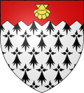 | The arms of Mortrée are blazoned : Ermine, on a chief indented gules an escallop Or.
|
Town twinning
Mortrée is twinned with towns are:
 Shrivenham, Oxfordshire – England.[14]

See also
References
- ^ "Répertoire national des élus: les maires" (in French). data.gouv.fr, Plateforme ouverte des données publiques françaises. 4 May 2022.
- ^ "Populations légales 2021". The National Institute of Statistics and Economic Studies. 28 December 2023.
- ^ Arrêté préfectoral 28 September 2018, modified 12 November 2018 (in French)
- ^ a b "Mortrée · France". Mortrée · France.
- ^ Sandre. "Fiche cours d'eau - L'Orne (I2--0200)".
- ^ "rapport de charte" (PDF), parc-naturel-normandie-maine.fr/
- ^ "MASSIF FORESTIER D'ECOUVES ET SES MARGES" (PDF). ZNIEFF.
- ^ "Nature - THE QUARRY OF THE VAUX - Saint-Hilaire-La-Gérard". www.petitfute.co.uk.
- ^ "Géologique de Normandie-Maine | RESERVES NATURELLES DE FRANCE". www.reserves-naturelles.org.
- ^ "Château d'O à Mortrée - PA00110871". monumentum.fr.
- ^ "Logis à Mortrée - PA00135525". monumentum.fr.
- ^ "Eglise Saint-Pierre à Mortrée - PA61000049". monumentum.fr.
- ^ "RENE HARDY, LEADER IN FRENCH RESISTANCE IN WWII, DIES AT 75". Washington Post.
- ^ "Shrivenham Parish Council - Twinning". www.shrivenham.org.
Wikimedia Commons has media related to Mortrée.
- v
- t
- e

- L'Aigle
- Alençonpref
- Almenêches
- Appenai-sous-Bellême
- Argentansubpr
- Les Aspres
- Athis-Val de Rouvre
- Aube
- Aubry-le-Panthou
- Aubusson
- Auguaise
- Aunay-les-Bois
- Aunou-le-Faucon
- Aunou-sur-Orne
- Les Authieux-du-Puits
- Avernes-Saint-Gourgon
- Avoine
- Avrilly
- Bagnoles de l'Orne Normandie
- Bailleul
- Banvou
- Barville
- Bazoches-au-Houlme
- Bazoches-sur-Hoëne
- La Bazoque
- Beaufai
- Beaulieu
- Beauvain
- Belfonds
- Belforêt-en-Perche
- Bellavilliers
- Bellême
- La Bellière
- Bellou-en-Houlme
- Bellou-le-Trichard
- Berd'huis
- Berjou
- Bizou
- Boëcé
- Boischampré
- Boissei-la-Lande
- Boitron
- Bonnefoi
- Bonsmoulins
- Le Bosc-Renoult
- Boucé
- Le Bouillon
- Brethel
- Bretoncelles
- Brieux
- Briouze
- Brullemail
- Buré
- Bures
- Bursard
- Cahan
- Caligny
- Camembert
- Canapville
- Carrouges
- Ceaucé
- Le Cercueil
- Cerisé
- Cerisy-Belle-Étoile
- Ceton
- Chahains
- Chailloué
- Le Chalange
- Champcerie
- Le Champ-de-la-Pierre
- Les Champeaux
- Champeaux-sur-Sarthe
- Champ-Haut
- Champosoult
- Champsecret
- Chandai
- Chanu
- La Chapelle-au-Moine
- La Chapelle-Biche
- La Chapelle-Montligeon
- La Chapelle-près-Sées
- La Chapelle-Souëf
- La Chapelle-Viel
- Charencey
- Le Château-d'Almenêches
- Le Châtellier
- Chaumont
- La Chaux
- Chemilli
- Ciral
- Cisai-Saint-Aubin
- Colombiers
- Comblot
- Commeaux
- Condé-sur-Sarthe
- Corbon
- Coudehard
- Coulimer
- Coulmer
- Coulonces
- La Coulonche
- Coulonges-sur-Sarthe
- Courgeon
- Courgeoût
- Cour-Maugis sur Huisne
- Courtomer
- Craménil
- Croisilles
- Crouttes
- Crulai
- Cuissai
- Dame-Marie
- Damigny
- Domfront en Poiraie
- Dompierre
- Durcet
- Échalou
- Échauffour
- Écorcei
- Écorches
- Écouché-les-Vallées
- Écouves
- Essay
- Faverolles
- Fay
- Feings
- La Ferrière-au-Doyen
- La Ferrière-aux-Étangs
- La Ferrière-Béchet
- La Ferrière-Bochard
- Ferrières-la-Verrerie
- La Ferté-en-Ouche
- La Ferté-Macé
- Flers
- Fleuré
- Fontaine-les-Bassets
- Francheville
- La Fresnaie-Fayel
- Fresnay-le-Samson
- Gacé
- Gandelain
- Gâprée
- Les Genettes
- La Genevraie
- Giel-Courteilles
- Ginai
- Godisson
- La Gonfrière
- Gouffern en Auge
- Le Grais
- Guêprei
- Guerquesalles
- Habloville
- Hauterive
- Héloup
- L'Hôme-Chamondot
- Igé
- Irai
- Joué-du-Bois
- Joué-du-Plain
- Juvigny-sur-Orne
- Juvigny Val d'Andaine
- Lalacelle
- Laleu
- La Lande-de-Goult
- La Lande-de-Lougé
- La Lande-Patry
- La Lande-Saint-Siméon
- Landigou
- Landisacq
- Larré
- Lignères
- Lignou
- Loisail
- Longny les Villages
- Lonlay-l'Abbaye
- Lonlay-le-Tesson
- Lonrai
- Lougé-sur-Maire
- Louvières-en-Auge
- Macé
- La Madeleine-Bouvet
- Le Mage
- Magny-le-Désert
- Mahéru
- Mantilly
- Marchemaisons
- Mardilly
- Mauves-sur-Huisne
- Médavy
- Méhoudin
- Le Mêle-sur-Sarthe
- Le Ménil-Bérard
- Le Ménil-Broût
- Le Ménil-Ciboult
- Le Ménil-de-Briouze
- Ménil-Erreux
- Ménil-Froger
- Ménil-Gondouin
- Le Ménil-Guyon
- Ménil-Hermei
- Ménil-Hubert-en-Exmes
- Ménil-Hubert-sur-Orne
- Le Ménil-Scelleur
- Le Ménil-Vicomte
- Ménil-Vin
- Les Menus
- Le Merlerault
- Merri
- La Mesnière
- Messei
- Mieuxcé
- Moncy
- Montabard
- Montchevrel
- Montgaudry
- Montilly-sur-Noireau
- Montmerrei
- Mont-Ormel
- Montreuil-au-Houlme
- Montreuil-la-Cambe
- Les Monts d'Andaine
- Montsecret-Clairefougère
- Monts-sur-Orne
- Mortagne-au-Perchesubpr
- Mortrée
- La Motte-Fouquet
- Moulins-la-Marche
- Moulins-sur-Orne
- Moutiers-au-Perche
- Neauphe-sous-Essai
- Neauphe-sur-Dive
- Nécy
- Neuilly-le-Bisson
- Neuville-sur-Touques
- Neuvy-au-Houlme
- Nonant-le-Pin
- Occagnes
- Ommoy
- L'Orée-d'Écouves
- Orgères
- Origny-le-Roux
- Pacé
- Parfondeval
- Le Pas-Saint-l'Homer
- Passais Villages
- Perche en Nocé
- Perrou
- Pervenchères
- Le Pin-au-Haras
- Le Pin-la-Garenne
- Planches
- Le Plantis
- Pointel
- Pontchardon
- Pouvrai
- Putanges-le-Lac
- Rai
- Rânes
- Rémalard en Perche
- Le Renouard
- Résenlieu
- Réveillon
- Ri
- Rives d'Andaine
- La Roche-Mabile
- Roiville
- Rônai
- Rouperroux
- Sablons-sur-Huisne
- Sai
- Saint-Agnan-sur-Sarthe
- Saint-André-de-Briouze
- Saint-André-de-Messei
- Saint-Aquilin-de-Corbion
- Saint-Aubin-d'Appenai
- Saint-Aubin-de-Bonneval
- Saint-Aubin-de-Courteraie
- Saint-Bômer-les-Forges
- Saint-Brice
- Saint-Brice-sous-Rânes
- Saint-Céneri-le-Gérei
- Saint-Christophe-de-Chaulieu
- Saint-Clair-de-Halouze
- Saint-Cyr-la-Rosière
- Saint-Denis-sur-Huisne
- Saint-Denis-sur-Sarthon
- Sainte-Céronne-lès-Mortagne
- Sainte-Gauburge-Sainte-Colombe
- Sainte-Honorine-la-Chardonne
- Sainte-Honorine-la-Guillaume
- Saint-Ellier-les-Bois
- Sainte-Marguerite-de-Carrouges
- Sainte-Marie-la-Robert
- Sainte-Opportune
- Sainte-Scolasse-sur-Sarthe
- Saint-Evroult-de-Montfort
- Saint-Evroult-Notre-Dame-du-Bois
- Saint-Fraimbault
- Saint-Fulgent-des-Ormes
- Saint-Georges-d'Annebecq
- Saint-Georges-des-Groseillers
- Saint-Germain-d'Aunay
- Saint-Germain-de-Clairefeuille
- Saint-Germain-de-la-Coudre
- Saint-Germain-de-Martigny
- Saint-Germain-des-Grois
- Saint-Germain-du-Corbéis
- Saint-Germain-le-Vieux
- Saint-Gervais-des-Sablons
- Saint-Gervais-du-Perron
- Saint-Gilles-des-Marais
- Saint-Hilaire-de-Briouze
- Saint-Hilaire-le-Châtel
- Saint-Hilaire-sur-Erre
- Saint-Hilaire-sur-Risle
- Saint-Jouin-de-Blavou
- Saint-Julien-sur-Sarthe
- Saint-Lambert-sur-Dive
- Saint-Langis-lès-Mortagne
- Saint-Léger-sur-Sarthe
- Saint-Léonard-des-Parcs
- Saint-Mard-de-Réno
- Saint-Mars-d'Égrenne
- Saint-Martin-d'Écublei
- Saint-Martin-des-Landes
- Saint-Martin-des-Pézerits
- Saint-Martin-du-Vieux-Bellême
- Saint-Martin-l'Aiguillon
- Saint-Michel-Tubœuf
- Saint-Nicolas-des-Bois
- Saint-Nicolas-de-Sommaire
- Saint-Ouen-de-Sécherouvre
- Saint-Ouen-le-Brisoult
- Saint-Ouen-sur-Iton
- Saint-Patrice-du-Désert
- Saint-Paul
- Saint-Philbert-sur-Orne
- Saint-Pierre-d'Entremont
- Saint-Pierre-des-Loges
- Saint-Pierre-du-Regard
- Saint-Pierre-la-Bruyère
- Saint-Quentin-de-Blavou
- Saint-Quentin-les-Chardonnets
- Saint-Roch-sur-Égrenne
- Saint-Sauveur-de-Carrouges
- Saint-Sulpice-sur-Risle
- Saint-Symphorien-des-Bruyères
- Saires-la-Verrerie
- Le Sap-André
- Sap-en-Auge
- Sarceaux
- Sées
- La Selle-la-Forge
- Semallé
- Sévigny
- Sevrai
- Soligny-la-Trappe
- Suré
- Tanques
- Tanville
- Tellières-le-Plessis
- Tessé-Froulay
- Ticheville
- Tinchebray-Bocage
- Torchamp
- Touquettes
- Tournai-sur-Dive
- Tourouvre au Perche
- Trémont
- La Trinité-des-Laitiers
- Trun
- Val-au-Perche
- Valframbert
- Vaunoise
- Les Ventes-de-Bourse
- La Ventrouze
- Verrières
- Vidai
- Vieux-Pont
- Villedieu-lès-Bailleul
- Villiers-sous-Mortagne
- Vimoutiers
- Vitrai-sous-Laigle
- Les Yveteaux
- pref: prefecture
- subpr: subprefecture
| Authority control databases: National |
|
|---|
 | This Orne geographical article is a stub. You can help Wikipedia by expanding it. |
- v
- t
- e


