Kaugama
LGA and town in Jigawa State, Nigeria
12°29′0″N 9°44′0″E / 12.48333°N 9.73333°E / 12.48333; 9.73333 Nigeria
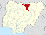
Kaugama is a Local Government Area in the north of Jigawa State, Nigeria. Its headquarters are in the town of Kaugama.
It has an area of 883 km2 and a population of 127,956 at the 2006 census.
The postal code of the area is 730.[1]
Climate
A scorching, mostly cloudy dry season with temperatures between 59°F and 104°F alternates with a humid, oppressive wet season that is hot and humid.[2]
Air Pollution
Kaugama faces air pollution from vehicles and dust, which pose significant health risks due to their small size and potential inhalation into the deepest parts of the lung.[3]
References
- ^ "Post Offices- with map of LGA". NIPOST. Archived from the original on 2009-10-07. Retrieved 2009-10-20.
- ^ "Kaugama Climate, Weather By Month, Average Temperature (Nigeria) - Weather Spark". weatherspark.com. Retrieved 2023-09-08.
- ^ "Air Quality & Pollen Forecast for Kaugama". meteoblue. Retrieved 2023-09-24.
- v
- t
- e
Jigawa StateState capital: Dutse
- Auyo
- Babura
- Biriniwa
- Birnin Kudu
- Buji
- Dutse
- Gagarawa
- Garki
- Gumel
- Guri
- Gwaram
- Gwiwa
- Hadejia
- Jahun
- Kafin Hausa
- Kazaure
- Kiri Kasama
- Kiyawa
- Kaugama
- Maigatari
- Malam Madori
- Miga
- Ringim
- Roni
- Sule Tankarkar
- Taura
- Yankwashi
Elleman Tijjani, Elleman hausawa, Dakayyawa, Hadin, Mand'a.
 | This Jigawa State, Nigeria location article is a stub. You can help Wikipedia by expanding it. |
- v
- t
- e


