Iwafune District, Niigata
You can help expand this article with text translated from the corresponding article in Japanese. (April 2023) Click [show] for important translation instructions.
- View a machine-translated version of the Japanese article.
- Machine translation, like DeepL or Google Translate, is a useful starting point for translations, but translators must revise errors as necessary and confirm that the translation is accurate, rather than simply copy-pasting machine-translated text into the English Wikipedia.
- Consider adding a topic to this template: there are already 3,691 articles in the main category, and specifying
|topic=will aid in categorization. - Do not translate text that appears unreliable or low-quality. If possible, verify the text with references provided in the foreign-language article.
- You must provide copyright attribution in the edit summary accompanying your translation by providing an interlanguage link to the source of your translation. A model attribution edit summary is
Content in this edit is translated from the existing Japanese Wikipedia article at [[:ja:岩船郡]]; see its history for attribution. - You may also add the template
{{Translated|ja|岩船郡}}to the talk page. - For more guidance, see Wikipedia:Translation.
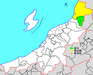
* yellow - areas formerly within the district borders during the early Meiji period
* green - current borders
- Awashimaura-mura
- Sekikawa-mura
Iwafune (岩船郡, Iwafune-gun) is a district located in Niigata Prefecture, Japan.
As of July 1, 2019, the district has an estimated population of 5,644 with a density of 18.2 persons per km2. The total area is 309.39 km2.
Municipalities
The district consists of two villages:
History
This list is incomplete; you can help by adding missing items. (March 2023) |
Iwafune's name is from the Ancient Japanese Ritsuryo System. In 1878, when Iwafune District launched, the district covered all six towns listed above and the current city of Murakami, and the district areas has been the same since the founding. The district seat was located at Murakami-Honmachi (now part of the current city of Murakami).
After the district lost Murakami in 1954, the district areas remain the same as until April 1, 2008. There had been some talks to merge with the city of Murakami but the city of Murakami killed the merger because of the city's new name. However, the talks was finally settled.
Recent mergers
- On April 1, 2008 - The towns of Sanpoku and Arakawa, and the villages of Asahi and Kamihayashi were merged into the expanded city of Murakami.[1][2]
Notes
- ^ a b Classified as a village.
References
- ^ 住民基本台帳人口移動報告年報 (in Japanese). 総務庁統計局. 2008. p. 133.
Murakami-shi, Arakawa-machi, Kamihayashi-mura, Asahi-mura and Sanpoku-machi were incorporated into a newly established Murakami-shi as of April 1, 2008.
- ^ "県内の合併状況 - 新潟県ホームページ" [The Status of the Merger Within the Prefecture - Niigata Prefecture Homepage]. Niigata Prefecture. Retrieved 2024-02-04.


Authority control databases | |
|---|---|
| International |
|
| National |
|
38°03′40″N 139°36′00″E / 38.061°N 139.60°E / 38.061; 139.60
 | This Niigata Prefecture location article is a stub. You can help Wikipedia by expanding it. |
- v
- t
- e


