Huaraz District
District in Ancash, Peru
Huaraz Waras | |
|---|---|
District | |
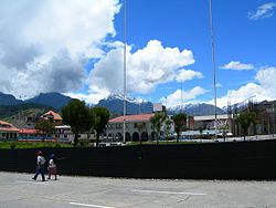 Main square in Huaraz with the Cordillera Blanca in the background | |
| Country |  Peru Peru |
| Region | Ancash |
| Province | Huaraz |
| Capital | Huaraz |
| Government | |
| • Mayor | Eliseo Rori Mautino Ángeles (2019-2022) |
| Area | |
| • Total | 432.99 km2 (167.18 sq mi) |
| Elevation | 3,052 m (10,013 ft) |
| Population (2005 census) | |
| • Total | 52,592 |
| • Density | 120/km2 (310/sq mi) |
| Time zone | UTC-5 (PET) |
| UBIGEO | 020101 |
Huaraz District is one of twelve districts of the province Huaraz in Peru.[1]
Geography
The Cordillera Blanca and the Cordillera Negra traverse the district. Some of the highest mountains of the district are listed below:[2]
- Antap'iti
- Kashan
- Kayish
- Kima Rumi
- Map'arahu
- Puka Hirka
- Qarwakancha
- Wamash Punta
- Wamashrahu
References
- ^ (in Spanish) Instituto Nacional de Estadística e Informática. Banco de Información Distrital Archived 2008-04-23 at the Wayback Machine. Retrieved April 11, 2008.
- ^ escale.minedu.gob.pe - UGEL map of the Huaraz Province (Ancash Region)
See also
- v
- t
- e

9°32′S 77°32′W / 9.533°S 77.533°W / -9.533; -77.533
 | This Ancash Region geography article is a stub. You can help Wikipedia by expanding it. |
- v
- t
- e


