Grand Island Harbor Rear Range Light
Lighthouse in Michigan, United States
Lighthouse
F W Grand Island Harbor Rear Range Light
The Grand Island Harbor Rear Range Light is a lighthouse located off M-28 in Munising Township, Michigan. It is also known as the Bay Furnace Rear Range Light, Christmas Rear Range Light,[7] or End of the Road Light.[8] The corresponding front range light was replaced in 1968; the rear range light was listed on the National Register of Historic Places in 1990.[6] It is no longer an active aid to navigation.
The grounds only are publicly accessible, but a hike is required.[9]
History
The Grand Island Range Lights were lit first in 1868.[1] The original front range light was a wooden pyramid that held a sixth-order Fresnel lens.[1] The original rear range light was a sixth-order Fresnel lens in a wooden tower atop a frame keeper's house,[5] 500 feet (150 m) to the rear of the front range light.[1]
By 1914, these original frame structures were severely rotted, and both were replaced[1] as part of a broader effort of replacing nearly all harbor lights with steel-framed structures.[2] The new front range light was a 23-foot-tall (7.0 m) iron mast.[1] A new automated[2] rear range light was installed 750 feet (230 m) to the rear of the front range light.[1] The new rear range light was a 64-foot (20 m) tower, the upper half (painted white)[10] of which was part of a tower originally located at the Vidal Shoals.[1] near Sault Ste. Marie.[10][11] In 1939, the sixth-order Fresnel lenses were replaced with 350 millimeter glass lenses, which still used acetylene gas.[5] In 1968, the front range light was replaced with a "D9" style tubular steel structure;[5] in 1969 the lights were deactivated.[2]
Rear range light description
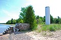
The 1914 Rear Range Light is a steel conical tower, 64 feet (20 m) high, with a round lantern.[2] The light of one of the tallest, if not the tallest, of the riveted steel plate light towers installed around the Great Lakes.[2][12] The tower sits on a concrete foundation; a metal door in the base of the tower and interior spiral stair provides access to the light. The tower is painted black on the bottom and white on the top, with a black lantern room. The existing light was built in 1914 replacing the original 1868 station.[2][13]
Gallery
-
 Interior of rear range light
 -
 1968 front range light; foundation of 1914 front range light is to left
 -
 Front range light, with rear in background


References
- ^ a b c d e f g h "Historic Light Station Information and Photography: Michigan". United States Coast Guard Historian's Office. Archived from the original on 2017-05-01. Retrieved 2010-01-01.
- ^ a b c d e f g "Grand Island Harbor Rear Range Light". state of Michigan. Archived from the original on 2011-06-06. Retrieved January 1, 2010.
- ^ Pepper, Terry. "Database of Tower Heights". Seeing the Light. terrypepper.com. Archived from the original on 2000-09-18.
- ^ Pepper, Terry. "Database of Focal Heights". Seeing the Light. terrypepper.com. Archived from the original on 2008-08-30.
- ^ a b c d Grand Island Range Lights Archived 2009-11-09 at the Wayback Machine from "Seeing the Light," Terry Pepper, retrieved 1/1/10
- ^ a b "National Register Information System". National Register of Historic Places. National Park Service. March 13, 2009.
- ^ "Great Lighthouses". US Forest Service.
- ^ "Grand Island Harbor Range Lighthouse". Lighthouse Friends.
- ^ Publicly accessible lights in Michigan, National Park System, Maritime Heritage Project.
- ^ a b GRAND ISLAND HARBOR RANGE LIGHTS (PDF), US Forest Service
- ^ Rowlett, Russ. "Lighthouses of the United States: Michigan's Eastern Upper Peninsula". The Lighthouse Directory. University of North Carolina at Chapel Hill.
- ^ Pepper, Terry. "Database of Tower Designs". Seeing the Light. terrypepper.com. Archived from the original on 2009-11-15.
- ^ Maritime History Project, Inventory of Historic Lights, Grand Island Harbor Rear Range Light, National Park Service
External links
Wikimedia Commons has media related to Grand Island Harbor Rear Range Light.
- Aerial photography, Grand Island West Channel Rear Range Lighthouse at Marinas.com.
- Grand Island Harbor Range Lighthouse (Bay Furnace) from the Michigan Lighthouse Conservancy
- Satellite view at Google Maps.
- GRAND ISLAND HARBOR RANGE LIGHTS from the US Forest Service
- v
- t
- e
- Au Sable
- Big Bay Point
- Copper Harbor
- Copper Harbor Front Range
- Crisp Point
- Eagle Harbor
- Eagle Harbor Range Lights
- Eagle River
- Fourteen Mile Point
- Grand Island East Channel
- Grand Island Harbor Rear Range
- Grand Island North
- Grand Marais Range Lights
- Granite Island
- Gull Rock
- Huron Island
- Isle Royale
- Manitou Island
- Marquette Breakwater Outer
- Marquette Harbor
- Mendota (Bete Grise)
- Munising Front Range
- Munising Rear Range
- Ontonagon
- Ontonagon Harbor West Breakwater
- Portage River (Jacobsville)
- Passage Island
- Presque Isle Harbor Breakwater Light
- Rock Harbor
- Rock of Ages
- Sand Hills
- Sand Point Light (Baraga)
- St. Martin Island
- Stannard Rock
- Thunder Bay Island
- Whitefish Point

- Frying Pan Island
- Pipe Island
- Point Iroquois
- Round Island Light (St. Mary's River)
- Six Mile Point Range Rear
- Winter Point Range Front
- Keweenaw Waterway Lower Entrance
- Keweenaw Waterway Upper Entrance
- Portage Lake
- Rouleau Point Range Front and Rear Lights
- Beaver Island Harbor
- Beaver Island Head
- Big Sable Point
- Cedar River
- Charlevoix
- Charlevoix South Pier
- Frankfort
- Frankfort South Range
- Grand Haven North Pierhead
- Grand Haven South Pierhead Entrance
- Grand Haven South Pierhead Inner
- Grand Traverse
- Grays Reef
- Holland Harbor
- Ile Aux Galets
- Little Sable Point
- Little Traverse
- Ludington
- Manistee Pierhead
- Manning Memorial
- Mission Point
- Mission Point (1933)
- Muskegon Breakwater
- Muskegon Pier
- North Manitou Shoal
- Pentwater North Pierhead
- Pentwater South Pierhead
- Point Betsie
- Portage Lake
- South Fox Island
- South Haven
- South Manitou Island
- St. Joseph North Pier Inner
- St. Joseph North Pier Outer
- Waugoshance
- White River
- White Shoal
- Alpena
- Caseville Harbor
- Charity Island
- Cheboygan Crib
- Cheboygan River Front Range
- Detroit River
- Fort Gratiot
- Forty Mile Point
- Fourteen Foot Shoal
- Gibraltar
- Gravelly Shoal
- Harbor Beach
- Lake St. Clair
- Mariners Memorial
- Middle Island
- Miller Memorial
- New Presque Isle
- Old Presque Isle
- Peche Island Rear Range
- Poe Reef
- Pointe aux Barques
- Port Austin
- Port Sanilac
- Saginaw Bay
- Saginaw River Rear Range
- Spectacle Reef
- St. Clair Flats Front and Rear Range Light
- Sturgeon Point
- Tawas Point
- Thunder Bay Island
- Tri-Centennial Light of Detroit
- William Livingstone Memorial
- Windmill Point
- Au Sable North Pierhead
- Belle Isle
- Clinton River
- Ecorse
- Ecorse Range Rear
- Gibraltar
- Grassy Island
- Grassy Island North Channel Range Lights
- Grassy Island South Channel Range Lights
- Grosse Ile North Channel Range Lights
- Grosse Ile South Channel Range Lights
- Harwood Point East Range Front
- Kalamazoo River
- Mama Juda
- Mama Juda Range Front
- Manistee Main
- Middle Lake George
- Monroe Pier
- New Buffalo
- North Manitou Island
- Saginaw Bay
- Sand Beach North Entrance East
- Squaw Point
- St. Mary's River Lower Range Front
- Vidal Shoals Channel Range Front and Rear Lights
- Windmill Point Range Front and Rear Lights
- Lightship Huron
- List of lifesaving stations in Michigan
- Wixom Lake, Musselman Island lighthouse
| |
|---|---|
| Topics | |
| Lists by state |
|
| Lists by insular areas | |
| Lists by associated state | |
| Other areas | |
| Related | |
| |


| Authority control databases: Geographic |
|
|---|


